
The ruins of the Trabuco Adobe, circa 1930 (courtesy the First American Corp.).
Mission Adobes and Outposts in Orange County
The typical image of the California missions is of a highly-centralized complex centered around the mission church. In fact, the missions were far-flung operations. The outposts of Mission San Luis Rey were spread out over nearly a thousand square miles. The Mission San Gabriel’s holdings stretched all the way east to the top of the San Gorgonio Pass.
Between them, missions San Gabriel and San Juan Capistrano made use of much of Orange County for farming and grazing. These mission outposts were described in various ways by the missionaries. Simplest were the ranchos, or sitios (sites). A little more permanent were the estancias (stations). Highest on the list were asistencias, often boasting large adobe complexes, and their own chapels. Some – like San Antonio de Pala, or Santa Ysabel in San Diego County – were virtually missions, lacking only a resident priest. Nothing in Orange County rose to that level. But several of San Juan Capistrano’s outposts could boast their own adobe buildings; in fact, portions of two or three of them still stand.
The Estancia Adobe
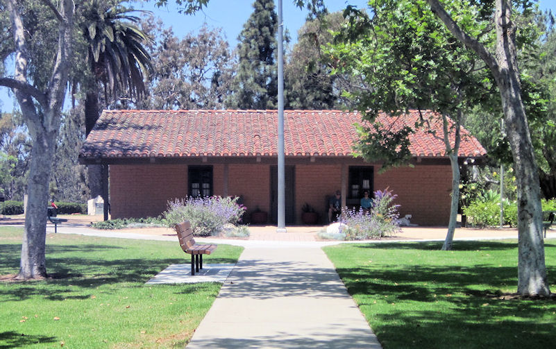
The best known is the estancia in Costa Mesa, in Estancia Park (1900 Adams Avenue) on the bluffs overlooking the Santa Ana River. Just when the adobe was built is unclear. In 1817 the padres at Mission San Juan Capistrano asked for permission to use the area at “Las Bajios de Santa Ana” (the shallows, or shoals of the Santa Ana River) but the adobe would have been built some time later. The Costa Mesa Historical Society’s website states: “Possibly as early as 1817, but more likely between 1820 and 1823, a small adobe was built to house the majordomo and his men. The large ‘mission’ bricks of this first structure were found in the east and south walls.” The adobe was certainly there by 1827, when a mission report mentions the “estancia de Santa Ana, on the bank of the river of the same name.”
Two other small adobes once stood nearby along the bluffs. The Polloreno, or Banning Adobe, was about a third of a mile south of Adams Street. It was destroyed in the early 1900s. The Rice Adobe was just north of Gisler; it was torn down in 1919. In his 1976 history of Costa Mesa, A Slice of Orange, local historian Ed Miller is unwilling to commit himself on the origins of these adobes. “Sometime after 1800 three little adobes were built along the bluffs overlooking the Santa Ana River,” he writes. “Probably all three were constructed in relationship to … Spanish interests Many theories have been advanced as to how and when these small buildings came into being. No one has been able to uncover enough evidence to prove beyond doubt the origins of all three…. It is believed that the Estancia was built by the padres from Mission San Juan Capistrano as a way station for herders.” The other two, he speculates, may have been built later.
The estancia adobe survived because it was rebuilt during the Rancho Era and continued to be occupied as a residence until the 1960s when it was presented to the City of Costa Mesa by the Segerstrom family.
(Those familiar with Orange County’s rancho era will recognize that this area was also part of the Rancho Santiago de Santa Ana, granted to the Yorba-Peralta family in 1810. This apparent overlap is probably explained by the fact that under Spanish law, both the mission and the rancheros only held temporary concessions – at the time, all of California was held to belong to the King. It’s probably also worth mentioning that San Juan Capistrano had been grazing cattle along the lower Santa Ana River since at least the 1790s, well before even the original Juan Pablo Grijalva concession of 1801.)
The Trabuco Adobe
A few ruins of the Trabuco Adobe still stand along Trabuco Creek, in O’Neill Regional Park, boxed in behind a historical marker for “San Francisco Solano,” where the Portolá Expedition camped nearby in 1769. (The Arroyo Trabuco Trail runs past the ruins; or it is easily accessible via the park gate near Arroyo Vista and Ria streets in Rancho Santa Margarita.)

Ruins of the Trabuco Adobe, 1980 (courtesy John Elliott).
Trabuco Creek was an important water source for Mission San Juan Capistrano, which grew crops and grazed livestock along its banks as far back as the 1770s. Just when the Trabuco Adobe was built upstream is not recorded. Orange County historian Jim Sleeper suggested it was built as early as 1806; other historians suggest a date as early as the 1790s. Certainly the mission was active in the area by then. Later the area around the adobe became part of the Rancho Trabuco, and the old adobe was occupied by ranchers and sheepherders until gutted by fire shortly after 1900. After that it was allowed to fall into ruins and simply melted away.
The San Mateo Adobe
Another mission adobe was located atop San Mateo Point, at the very southern tip of Orange County, near President Nixon’s former Western White House in San Clemente (an area that is still private property). Both of the Trabuco and San Mateo adobes were located near important Indian villages – Alauna on Trabuco Creek, and Pange (pan-hay) along San Mateo Creek. One of these mission ranchos was probably the one authorized by the governor in 1788 since they were among the earliest of Capistrano’s outposts.
Once again, no construction date is available, but the San Mateo Adobe seems to have been occupied until the 1860s and was still used as a navigational landmark by ships in the 1880s. In the mid-1930s Capistrano folk historian Alfonso Yorba described the adobe as “a large, tile-roofed adobe of three or four rooms,” which had been “destroyed only recently.” This suggests it was similar in appearance to the Trabuco Adobe.
The Ciénega Adobe
A fourth mission adobe once stood on a little rise above the San Diego Creek Channel in what is now the San Joaquin Wildlife Sanctuary in Irvine (along Riparian View, south of Michelson Drive). This area was generally called the Ciénega or San Joaquin ranch in mission records. The ciénega was the famed Ciénga de las Ranas (Frog Swamp) that stretched from the top of the Back Bay almost to the foot of Red Hill. Capistrano was grazing cattle there by the 1790s, and their 1827 land report notes they were still grazing stock there three decades later. Rancho records speak of the “casa vieja” (old house) on the Rancho San Joaquin in the mid-1830s. Ranchero José Andrés Sepulveda may have occupied the adobe briefly before building his own headquarters across San Diego Creek. The missionaries complained that he also seized all of Capistrano’s cattle and horses in the area. Archaeological investigations suggest the adobe was in use until at least the 1860s, but not a hint of it remains visible today.
The Pryor Adobe
Another mission-era structure would seem to be the Pryor Adobe, between the mission and the sea. While the land around it was of little use for farming, the cove beyond (now Dana Point Harbor) was valuable for trading purposes. Above are the cliffs where men like Richard Henry Dana famously tossed cattle hides while American ships waited anchored well out to sea. A corral was located at the top of the cliffs (near where the gazebo is today) and it seems that the Pryor Adobe was originally built to store hides while waiting for the trading ships to arrive. Dana mistakenly described it as “the small white mission of San Juan Capistrano, with a few Indian huts about it, standing in a small hollow, about a mile from where we were [at the top of the cliffs].”
Like the estancia adobe, the Pryor Adobe has survived because it was taken over as a rancho building, serving in later years as the headquarters for the Rancho Boca de la Playa. It is still a private residence today.
San Juan Hot Springs
It has been suggested that San Juan Capistrano also had an adobe near San Juan Hot Springs, in the upper end of today’s Casper’s Wilderness Park. Certainly the springs were used by the missions as a place of rest and recuperation, and mission cattle no doubt grazed in the “Cerro de Trabuco” (the Santa Ana Mountains). Agua Caliente is listed as one of the mission ranchos in 1842, shortly after the Mexican government seized control of the California missions. This may have included the three little potreros (pastures) later granted to Juan Forster at Los Pinos in Orange County, and El Carrizo and La Ciénega in Riverside County. But whether Mission San Juan Capistrano had an adobe at the hot springs is still an open question.
It has sometimes been suggested that the Sievers Adobe, a quarter mile northeast of the springs, just off the Ortega Highway, was built by the mission in the 1820s. Other writers have favored a date more like the 1870s. I would suggest that the adobe’s location off away from the springs and just barely outside the boundaries of the Rancho Mission Viejo would seem to indication a post-mission era construction date. The canyon later became a lease cabin tract in the Cleveland National Forest, but the adobe was burned in a wildfire in 1993 and the remains later cleared by the Forest Service.
Citing no sources, Alfonso Yorba once claimed that “An adobe headquarters for the [Agua Caliente] rancho, probably including a chapel, stood near the [hot springs] well into the 1860s. It had a wide corridor facing the springs. No trace remains today of the former mission activity at this spot.” (Santa Ana Journal, 12-23-1935) An adobe is a possibility, but it certainly did not have a chapel. During the second half of the 19th century the hot springs became a popular tourist spot, and a resort hotel operated there from the 1880s until 1936. Today the area is closed to the public, only accessible through occasional hikes offered by the county park.
Other Sites
The Arroyo de la Misíon Vieja (San Juan Creek) was one of the primary water sources for Mission San Juan Capistrano, and used for both farming and grazing livestock, but the so-called Mission Viejo (Misíon Vieja) adobe near the mouth of Gobernadora Canyon is not the old mission site (which was further down the canyon); in fact, it does not seem to be a mission-era adobe at all. The best evidence is that it was built by Juan Forster around 1845. The adobe had fallen into ruin long before 1900, but traces of it were still visible in the 1960s.
Other San Juan Capistrano mission outposts mentioned in the early records include Laguna (by 1827) – probably meaning the area around the head of Laguna Canyon; Niguel (or Niguil, or Yuiguilli – the spelling is somewhat erratic), along Aliso Creek, in the Laguna Hills area (in the 1930s, Alfonso Yorba claimed there were remains of the mission’s tallow vats still buried near the site of one of the later Avila adobes); and El Toro. That name was in common use by 1837. Five years later the area was granted as the Rancho Cañada de los Alisos. None of these outposts seem to have had any adobe buildings, though temporary structures may have once stood there.
Mission San Gabriel
Mission San Gabriel does not seem to have had any adobes on their outposts in Orange County. In December 1827, Fr. José Sanchez reported that in 1815 Governor Argüello had assigned “the whole valley of the Río de San Gabriel, besides the Cañada Verde with Los Coyotes, to the mission. This district is occupied by the cattle and, at certain times, by the sheep, and even by the pigs. Likewise, it is to be observed that by permission of the ranchero Juan José Nieto, the mission uses for cattle the localities called Cerritos and Bolsa, belonging to said rancho…. [T]he rancho of the late Sergeant Antonio Yorba is contiguous to the lands of the mission, [but] the mission does not know what boundaries it has and how far his rancho extends.” A December 1828 report mentions four (unnamed) sitios on the “rancho de los Nietos y Coyotes” – at least some of which would have been in Orange County.
Los Coyotes, Cerritos, and Bolsa are all recognizable as rancho names. Los Coyotes would be in the Buena Park area. The Rancho Las Bolsas stretched from Garden Grove down to the coast, along the west side of the Santa Ana River. The Cañada Verde would seem to be one of the upper forks of Coyote Creek, and like Los Cerritos, was probably in Los Angeles County.
Rancho Las Bolsas
Both San Juan Capistrano and San Gabriel used lands on the Rancho Las Bolsas. As early as the 1790s, Mission San Juan Capistrano was grazing cattle north of the Santa Ana River in the Fountain Valley/Huntington Beach area. “[O]n the other side of the [Santa Ana] river,” the padres reported in 1827, the mission “possesses a stretch of land where for more than thirty years the cattle grazed. Now it has to sow the grain there…. The field which is found on the other side of the river may be five leagues [about 13 miles] in circumference, and adjoins the lands of the Nietos and those of Mission San Gabriel….”
An 1858 map of the adjoining Rancho Bolsa Chica (in the Huntington Beach area) shows a “Cienega called the corral de San Gabriel” in the Midway City area, just east of Beach Blvd. near McFadden Ave. Mission-era construction would also seem to be the best explanation for the adobe ruins that once stood near Ward and McFadden in Fountain Valley – known in the mid-19th century as simply Las Paredes (The Walls). Historian Don Meadows wrote that the adobe there was washed out by heavy rains in 1811.
Santa Ana Canyon
The 1828 inventory for Mission San Gabriel also lists an outpost along the north side of the Santa Ana Canyon in the Yorba Linda/Chino Hills area. This area was generally known as Santa Ana del Chino, to distinguish it from the area along the lower Santa Ana River. San Gabriel objected when Bernardo Yorba requested a grant on the north side of the Santa Ana Canyon in 1834. Fr. Tomás Esténaga complained that the area “is not barren land, but occupied by property of the mission” including cattle and horses, as part of their Rancho de Santa Ana. It was also reported that as long ago as 1824, the mission’s mayordomo, Francisco Feliz, had destroyed a corral constructed north of the river by Yorba’s cousin, Juan Pablo Peralta. But it was no use, and the grant went to Yorba.
So it went for all of the former mission lands in the 1830s and ‘40s. In theory, the missions held all of this land in trust for their Indian converts. Also in theory, it was supposed to be divided up among them when the Mexican government secularized the missions in the early 1830s. Instead, almost all the mission lands in Orange County were granted as ranchos to Mexican Californios – often the same men who had been appointed to look after the mission estates during the transition. The Nietos re-asserted their rights to lands west of the Santa Ana River in 1834, when the area was formally granted as five separate ranchos, including Los Coyotes, Los Cerritos, and Las Bolsas. San Juan Capistrano lost their grazing lands one by one in the 1830s and ‘40s until by the time of the American takeover, there was nothing left. Even the mission buildings and the church itself were sold off by Pío Pico, the last Mexican governor of California. But the United States government held the sale illegal, and the main mission compound was returned to the Catholic Church in 1865.