Orange Bicentennial Markers
During the United States Bicentennial celebration (1975-77) the Orange Bicentennial Commission placed more than two dozen historical plaques. Most of the plaques were placed at schools within the Orange Unified School District; which is not surprising, since the chairman of the commission was Gene Beyer, an OUSD junior high school principal (and future Mayor of Orange). Two of the plaques seem to have disappeared; two others were never placed. In 2011-12, with encouragement from the Orange Community Historical Society, two of the “missing” plaques were re-installed. Here is the list of all the plaques:

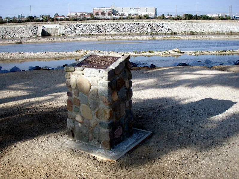
Remnants of some of the SAVI water works near the center of Eisenhower Park.
MOUTH OF THE SANTA ANA VALLEY IRRIGATION CO. TUNNEL
The 1870 irrigation ditch of A.B. Chapman and Andrew Glassell, which supplied water to the new farms and ranches around Orange, was diverted in 1878 to flow through a tunnel under the hills north of here. In 1892 the original redwood structure threatened to collapse. To alleviate the danger the old tunnel was lined with concrete. On April 14, 1892, over 2,000 people assembled here to witness the opening of the new tunnel.
Erected by the Santa Ana Valley Irrigation Co., February 3, 1976.
Orange Bicentennial Commission
Located near the northwest corner of Eisenhower Park, 2864 N. Tustin Street

The Olive Mill.
FIRST SITE OF THE OLIVE MILL
The 3-story flour and feed mill established by Thomas Dillin and his sons began operation November 4, 1882. Its motive power was derived from a turbine turned by Santa Ana River irrigation water flowing down to the valley below. On Sept. 29, 1889, fire razed the structure. Due to its vital function in early Orange County’s economy, it was rebuilt. The second site was in the s.w. corner of this park. It continued in operation there until 1932.
Erected by the Orange North Rotary Club, February 3, 1976.
Orange Bicentennial Commission
Located along the west side of Eisenhower Park near the center of the park, 2864 N. Tustin Street
ORANGE’S FIRST PUBLIC SCHOOLHOUSE

Florence Smiley, who attended classes on this site in the 1890s, unveils the plaque, March 26, 1976. Assisting are Orange Unified School District Trustee Ruth Evans, OUSD Superintendent Donald Ingwerson, and Maxine Schenck of the Association of California School Administrators. (Photo by Phil Brigandi)
Orange’s first public schoolhouse was completed here in June 1872. E.W. Squires, Amos Travis, and Elton R. Nichols, trustees for the Richland (Orange) School District, had contracted for a building that was 24 x 26 x 14 feet, for the 70 pupils that were present on opening day. A.B. Chapman deeded the land to the trustees for $1 and the benefit of education. Chapman’s gift of the 2½ acre site contained the restriction that it was to be used solely for the purpose of a public school. Stephen McPherson, according to tradition, first taught here; Isabel Squires and Robert Furlong are known to have followed.
This marker erected by the Association of California School Administrators, Orange Chapter, and the Orange Unified School District, March 26, 1976.
Orange Bicentennial Commission
Located a short distance southwest of its original location near the entrance to the Chapman University Law School, at 370 S. Glassell Street

El Camino Real plaque, 1987 (courtesy the Orange Public Library and History Center).
EL CAMINO REAL
The lower branch of the meandering trail known as El Camino Real, and indicated on old maps as Camino que va para San Juan Capistrano, passed near here. This pathway for grey-robed friar, mounted ranchero, and creaking carreta traveling between the missions of San Juan Capistrano and San Gabriel was the same route used by the coastline stages running between Los Angeles and San Diego in the late 1860’s.
This marker erected by Portola and Sycamore PTA, April 30, 1976.
Orange Bicentennial Commission
Located on the grounds of Sycamore Elementary School (in the rear, near the Orange Little League headquarters), 340 N. Main Street

THE ORANGE PLAZA
The Orange Plaza boundaries were established by the first survey of the site of Richland. This gift to the town, by A.B. Chapman and Andrew Glassell, has been the focal point for local festivals and activities for over 100 years. After determined efforts to make it a square were defeated in 1886, the first fountain (now in Hart Park) was placed here through the fund-raising efforts of the women of Orange.
This marker erected by the Orange Rotary Club, May 15, 1976.
Orange Bicentennial Commission
Located on the east side of the Plaza Fountain

Orange's first bank.
ORANGE’S FIRST BANK
The Bank of Orange, organized in 1886, was the first bank in the City of Orange and occupied this site. In 1887 the Bank of Orange changed its name to National Bank of Orange. The First National Bank of Orange, chartered in April 1906, was located at the northeast corner of Glassell and the Plaza. In 1911 the bank moved to the southeast corner of Chapman and the Plaza. In 1927, First National Bank and the National Bank of Orange merged, under a federal charter, as First National Bank of Orange. In 1963, First National Bank of Orange, because of its growth plans, changed its name to First National Bank of Orange County.
This marker erected by the First National Bank of Orange County, May 15, 1976.
Orange Bicentennial Commission
Located on the south side of the old First National Bank building (now Wells Fargo) at 101 E. Chapman Avenue

Campsite of Stockton and Kearny.
STOCKTON AND KEARNY CAMPSITE
The United States forces of General Stephen Watts Kearny and Commodore Robert Field Stockton, on orders to retake Los Angeles, camped near here on January 6, 1847. Their men slept that night in a Yorba irrigation ditch, which ran between the Yorba settlement, Santa Ana Viejo, and the Santa Ana River. Their defeat of the Mexican forces, near Los Angeles, on January 9, 1847, ended Mexican rule in California.
This marker erected by the Canyon Women’s Club, Girl Scout Troop 79, and Cadette Troop 167, June 4, 1976.
Orange Bicentennial Commission
Located on the north side of the 600 block of Riverdale Avenue
FIRST ORANGE COUNTY ORANGE GROVE

Orange County's first commercial orange grove.
The first successful commercial orange grove in what is now Orange County was planted near here by Patterson Bowers in 1873. Accounts of the time placed his ranch about two miles east of Orange (Richland), on the south side of Walnut Avenue near the Santiago Creek. When Bowers recalled planting his 80 acres he remarked, “There was not even a shrub save cactus and sagebrush.”
This marker erected by the American Association of University Women, June 5, 1976.
Orange Bicentennial Commission
Located at Prospect Elementary School, 379 N. Prospect Street

Re-dedication of the McPherson plaque, November 2011.
McPHERSON TOWN
In 1872, Stephen and Robert McPherson purchased 80 acres of raw land and planted Muscat grapes. A prosperous raisin industry developed, a packing house constructed, and more than 400 people were employed. In June, 1886, a post office was opened and in 1888 the town of McPherson was created. Vine disease destroyed the vineyards and the raisin industry, real estate values collapsed, and in 1900 the town was abandoned.
This marker erected by McPherson Junior High School Student Body, June 7, 1976.
Orange Bicentennial Commission
Located in front of McPherson Magnet School at 333 S. Prospect Street
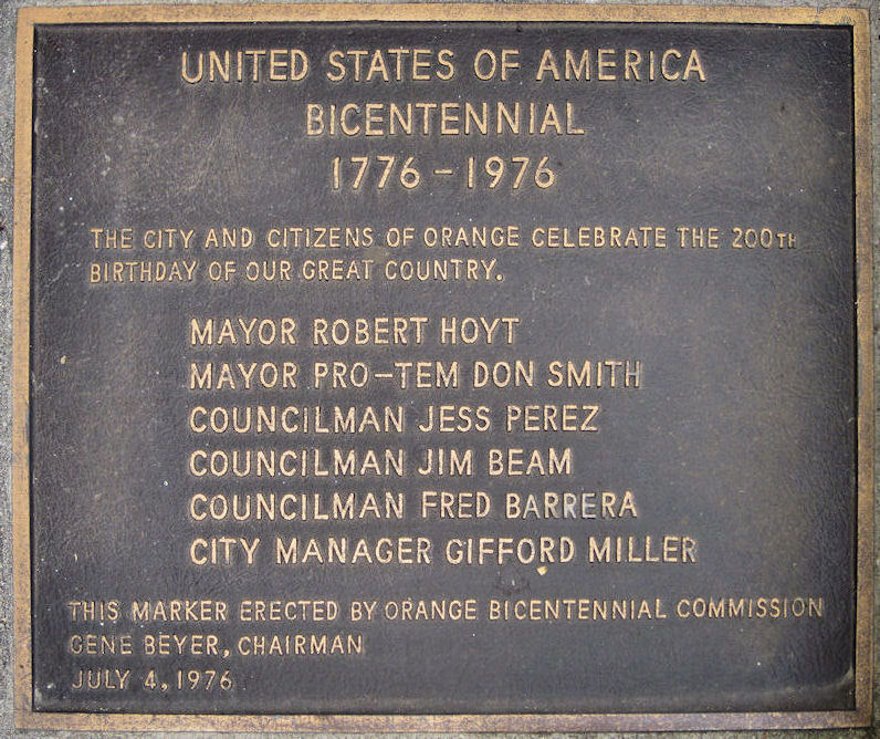
United States Bicentennial celebration.
UNITED STATES OF AMERICA BICENTENNIAL 1776-1976
The city and citizens of Orange celebrate the 200th birthday of our great country
Mayor Robert Hoyt
Mayor Pro-Tem Don Smith
Councilman Jess Perez
Councilman Jim Beam
Councilman Fred Barrera
City Manager Gifford Miller
This marker erected by Orange Bicentennial Commission, Gene Beyer, Chairman, July 4, 1976.
Located in front of the Orange Civic Center, 300 E. Chapman Avenue
JOHN C. FREMONT CAMP

John C. Fremont camp.
Major Fremont and the California Battalion marched from San Diego to join Commodore Robert F. Stockton in the first (August 13, 1846) occupation of Los Angeles. California’s Governor Pio Pico, fleeing to Mexico to avoid capture by the Americans, later reported that Fremont had camped at the house of Jose Antonio Yorba III, near this site, while he (Pico) hid at Santa Ana Viejo, now known as Olive.
This marker erected by the Orange Suburbia Kiwanis Club, July 28, 1976.
Orange Bicentennial Commission
Located in the sidewalk in front of 1929 W. Chapman Avenue

Dedication day for the upper El Camino Real plaque, September 28, 1976 (courtesy the Orange Public Library and History Center).
EL CAMINO REAL
The upper branch of the meandering trail known as “El Camino Real” was established by Captain Gaspar de Portola in 1769. After 1810, the Yorba settlement (Santa Ana Viejo), just below this site, served as a halfway rest stop for the weary travelers on the road between San Juan Capistrano and San Gabriel or Los Angeles. Tomas Yorba’s hide-laden carts, conquering enemies, and footsore friars all passed this way.
This marker erected by the Orange-Villa Park Kiwanis, September 28, 1976.
Orange Bicentennial Commission
Located at Olive Elementary School, 3038 N. Magnolia Avenue

ST. JOHN’S LUTHERAN SCHOOL
St. John’s Lutheran School, the first parochial school in the City of Orange, began in 1882 with the first building being dedicated on February 11, 1883. This building was located on a site five blocks to the west on the corner of Almond and Olive Street.
This marker erected by St. John’s Lutheran School, September 29, 1976.
Orange Bicentennial Commission
Located on the south side of the school in the 400 block of East Almond Avenue

Villa Park Elementary School.
VILLA PARK SCHOOL
In 1881, Joel B. Parker initiated the formation of the Mountain View School. There were 23 pupils officially enrolled under Mrs. Julia Abbott Foster, the district’s first teacher. The first schoolhouse was on the north side of Santiago Creek as Santiago Blvd., on the ranch of James Montague Smith. The first frame school building, with an octagon “out back,” was erected here in 1883 by Mr. Parker. In 1910, the district’s name was changed to Villa Park.
This marker erected by the Villa Park Eager Beavers 4-H Club, October 3, 1976.
Orange Bicentennial Commission
Located at Villa Park Elementary (at the southeast corner of the campus), 10551 Center Drive, Villa Park

St. James plaque, 1987 (courtesy the Orange Public Library and Local History Center).
ST. JAMES
Rampant land speculation swept Southern California in 1886 and 1887. Fertile fields were dotted with surveyors’ stakes and flags, marking town lots and avenues. Eager speculators bid for lots in the new towns. Saint James (Santiago), roughly bounded by Lincoln and Taft avenues, Canal Street, and the Santa Fe Railroad tracks, was typical. Its lots sold well. A store and livery stable were built and a hotel was planned. In 1889, barley again grew in its streets.
This marker erected by the Peralta Associated Student Body and Parent Faculty Organization, October 6, 1976.
Orange Bicentennial Commission
Originally located at Peralta Junior High School, 2190 Canal Street; now gone

Original location of the Palmyra Hotel plaque, 1983; the palm trees date back to the 1880s.
PALMYRA HOTEL
On July 28, 1887 the Palmyra Hotel was opened here during the peak of a widespread Southern California land boom. This local landmark stood three stories in height and contained a large dance hall. The hotel served as a social and cultural center in early Orange after the boom, and was later turned to apartments. The structure was demolished in 1970.
This marker erected by the Orange Host Lions Club, October 13, 1976.
Orange Bicentennial Commission
Located a short distance west of its original location at 301 S. Glassell Street

The El Modena Friends Church (now part of Moreno's Mexican Restaurant).
FRIENDS CHURCH
In 1886, a colony of Friends organized the town known first as Modena, then Earlham, and finally El Modena. Their church was built on land donated by W. Brown, W. Sharpless, W. Taylor, and C. Way, and was dedicated November 6, 1887. The 40 x 60 foot building, valued at $3,000, was smashed by Santa Ana Winds in December 1887, but was rebuilt a year later. This site served the Friends for 80 years. The original bell is still used at the new location.
This marker erected by Cosmopolitan International of Orange, November 4, 1976.
Orange Bicentennial Commission
Located on the front of the original church, now the banquet room at Moreno’s Mexican restaurant at 4328 E. Chapman Avenue

The route of Portolá.
ROUTE OF PORTOLA
Captain Gaspar de Portola and his party of leather-jacketed soldiers passed near here and made camp at the Santa Ana River on July 28, 1769. Portola’s company comprised the first explorers of Alta California. They and the Franciscan Friars began the settlement of California. The trail they broke in 1769 came to be known as El Camino Real.
This marker erected by Serrano Home and School League, Serrano Students, Associated Student Boyd of Cerro Villa, Cerro Villa Parent-Faculty Club, December 13, 1976.
Orange Bicentennial Commission
Located at Serrano Elementary School, 177741 Serrano Avenue, Villa Park

An octagon-shaped plaque for the Octagon House.
OCTAGON HOUSE
In 1870 Joel B. Parker, his wife, Mary, and daughter Ida came to Orange County. They purchased acreage from the Leandro Serrano allotment and completed the Octagon House in 1876. This site faced onto Villa Park Road (Katella). Cement used in construction was hauled from Colton in Mr. Parker’s freight wagons. Furniture for the house was carried in sailing ships around Cape Horn. The house had a third story tower room from which the family could enjoy a 360o view of the home and ranch. The Octagon House was a tourist attraction for many years, but it fell into disrepair and was demolished in 1965.
This marker erected by the First National Bank of Orange County – Villa Park Branch, Orange Kiwanis Club, and Katella School Association, December 14, 1976.
Orange Bicentennial Commission
Located at the southeast corner of the Orange Unified School District offices (formerly Katella Elementary School), 1401 N. Handy Street
The Anza campsite marker in its new location.
CAMPSITE OF ANZA
On September 29, 1775, Juan Bautista de Anza, with a party of over 200 emigrants and soldiers, set out from the presidio at Tubac, Mexico, to found San Francisco. His party reached the San Gabriel Mission on January 4, 1776, after many miles of torturous travel. Here they learned that Indians had burned the San Diego Mission and murdered Father Luis Jayme. Anza and part of his escort were ordered to ride immediately to San Diego to assist in suppressing the Indian rebellion. The Anza relief party made its first camp near here on January 7, 1776.
This marker erected by Orange Bicentennial Commission, December 15, 1976.
Located at the northeast corner of Riverdale and Orange-Olive Road [Relocated in 2012 to the Santa Ana River trail, just a few yards north]

The community of Peralta.
PERALTA
Sometime after 1814, Juan Pablo Peralta I, co-grantee of the Rancho Santiago de Santa Ana, built his adobe home east of here. His children, and their children in turn, built theirs near his. In 1871 Peralta was comprised of a small cluster of adobe homes belonging to Ramon Peralta, Gertruda Peralta Moreno, Nieves Lopez Peralta, Paula Peralta Dominguez, Trinidad Peralta Marquez, and Josefa Peralta Feliz. Today, the Ramon Peralta Adobe is the only surviving structure.
This marker erected by Orange Rotary Anns, December 16, 1976.
Orange Bicentennial Commission
Located at Imperial Elementary School, 400 S. Imperial Highway, Anaheim

May Festival plaque at the Plaza Fountain.
MAY FESTIVAL
The annual May Festival, a traditional celebration in the Orange community began in the 1880’s. It was held in the Irvine Park area as a harvest festival in May of each year by Orange and surrounding communities. The festival and parade were later moved into Orange and sponsored by the Chamber of Commerce. In 1960 the Orange Jaycees assumed sponsorship of this important annual community event.
This marker erected by the Orange Jaycees, December 20, 1976.
Orange Bicentennial Commission
Located on the north side of the Plaza Fountain

Dedication of the Seeley Stage Line marker, December 30, 1976. Orange Bicentennial Commission Chairman Gene Beyer at center.
SEELEY STAGE LINE
In 1868 the Concord coaches of Alfred L. Seeley’s San Diego-Los Angeles Stage Line passed near here. At 5 A.M. on Mondays, Wednesdays, and Fridays, passengers embarked from the stage office in the saloon of the Franklin Hotel in Old Town, San Diego, on the two-day trip to Los Angeles. They arrived at San Juan Capistrano at 7 P.M., stayed overnight, then proceeded to Los Angeles arriving at the Bella Union Hotel at 4 P.M.
This marker erected by Western Thrift and Loan Association, December 30, 1976.
Orange Bicentennial Commission
Originally located at Anaheim Stadium; now gone.

West Orange Elementary School.
FIRST WEST ORANGE SCHOOL
The first West Orange School was constructed in 1886 and continued in use until 1907. The site of that one room structure is three-fourths of a mile from here on the south-east corner of La Veta and Flower streets, which is now a complex of freeways. In 1924, West Orange School was moved to this site. The first principal of record was Mrs. Lotta H. Brandon, and Mrs. Mason Squires organized the first West Orange P.T.A. The present school was established in 1965.
This marker erected by the West Orange P.T.A. and Irmgard Quimilman, June 14, 1977.
Orange Bicentennial Commission
Located at West Orange Elementary (on the north side of campus), 243 S. Bush Street
[The first West Orange School was actually built in 1890 – p.b.]

Robert D. Hoyt orange grove at Hart Park.
ROBERT D. HOYT MUNICIPAL ORANGE GROVE
The planting of this grove in 1975 is a lasting reminder of the contribution of the citrus industry to the community of Orange and of Mayor Robert D. Hoyt who gave countless hours of dedicated service to the City of Orange.
Mayor Robert D. Hoyt
Mayor Pro-Tem Don Smith Councilman Fred Barrera
Councilman Jess Perez Councilman Jim Beam
This marker erected by the Orange City Council, September 2, 1977.
Orange Bicentennial Commission
Located in the southwest corner of Hart Park on the east side of the grove, 701 S. Glassell Street
[Originally marked as Orange Orchard Park; named for Mayor Hoyt when he left office in 1980.]

Plaques in front of the Ainsworth House (no longer owned by the city).
LEWIS AND PERSIS AINSWORTH
Lewis Ainsworth (1829-1914) and his wife Persis (1837-1933) chose the City of Orange as their home in 1901 after making their fortunes panning gold in California and farming in Kansas. The Ainsworths raised three sons, Lewis, Frank, Mitt and two daughters, Eva and Ina. Frank was the Mayor of Orange from 1918-1920 and Mitt was a Councilman from 1922-1926. Lewis built the Ainsworth Block on the Plaza Square in 1907 and founded the first lumber company in Orange. This house, designed by their daughter Ina Butler and built in 1910, reflects the simple life of the elderly couple. The restoration of the house was initiated by the Orange Bicentennial Commission and Councilman Don E. Smith. The home is listed on the National Register of Historic Places.
Orange Bicentennial Commission
1776 1976
Gene Beyer, Chairman
Located at 414 E. Chapman Avenue
Map of Orange's Bicentennial plaques produced at the time (click to enlarge).
(Planned but never placed were plaques for the Bluelight Mine in Silverado Canyon and the site of the West Orange Southern Pacific railroad depot.)